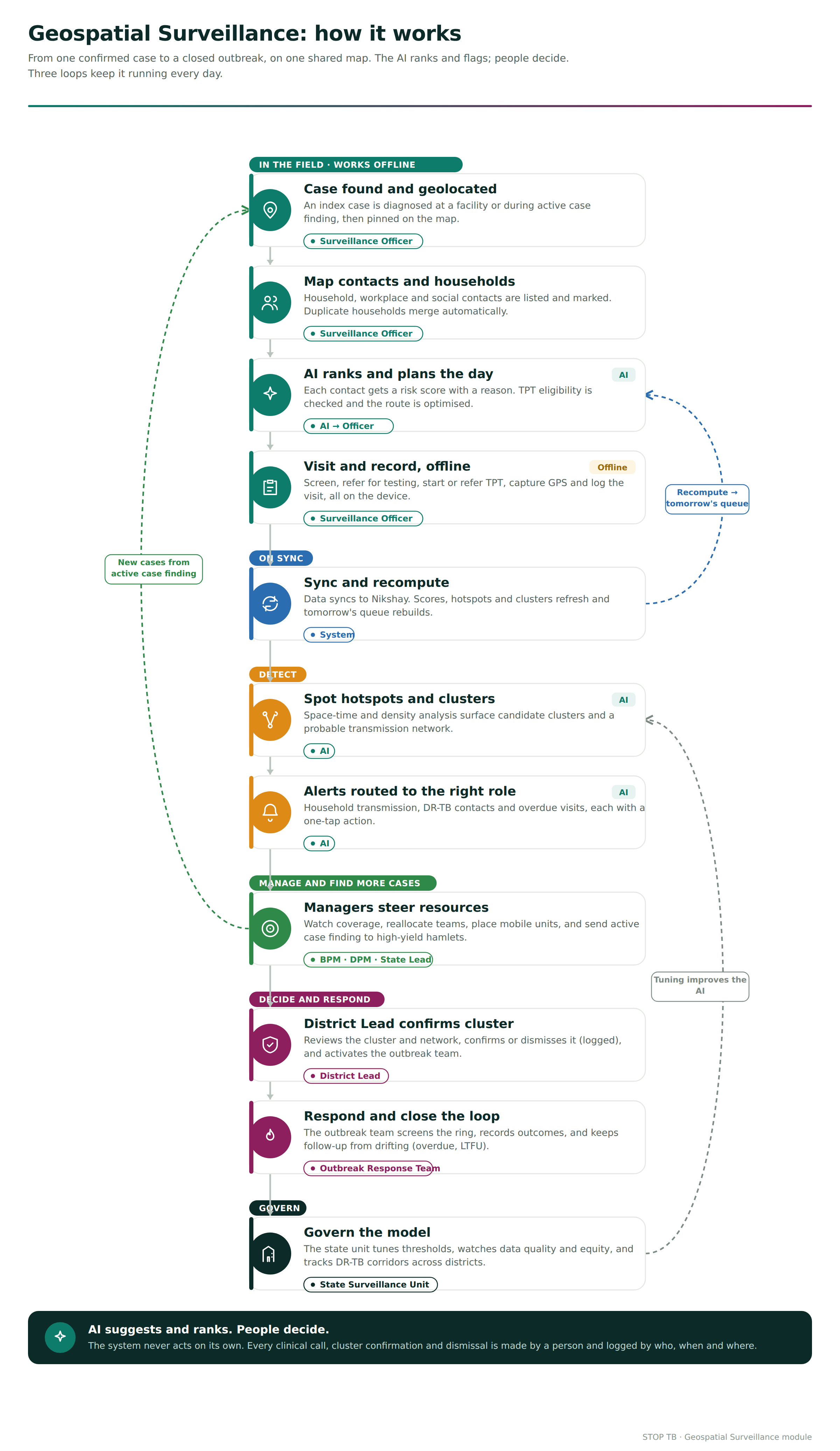
...
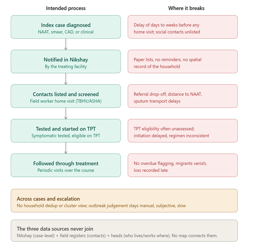
An index case is diagnosed (NAAT, smear, CXR-based CAD, or clinical) at a health facility or during active case finding.
The case is notified in Nikshay by the treating facility.
Household contacts are meant to be listed and screened. In practice this depends on a field worker (TBHV/STS/ASHA) visiting the home, asking about symptoms, and recording contacts on paper or in a basic form.
Symptomatic contacts are referred for testing. Asymptomatic eligible contacts (household contacts, especially children under five and people living with HIV) are meant to be evaluated for TPT and initiated.
Contacts and the index case are followed through treatment with periodic visits.
Where it breaks
Stage | Bottleneck / gap |
Index notified —› contacts listed | Delay of days to weeks before anyone visits the home. Occupational and social contacts rarely captured at all. |
Contacts listed —› screened | Paper lists; no reminders; incomplete symptom capture; no spatial record of the household. |
Screening —› testing | Referral drop-off; distance to nearest NAAT site; sputum transport delays. |
Eligible —› TPT initiated | TPT eligibility often not assessed; initiation delayed; regimen choice inconsistent. |
Follow-up of cases | No overdue-visit flagging; No deduplication of households, no cluster view, duplicated visits, missed households. |
Escalation | Cluster/outbreak judgement is manual, subjective, and slow. |
2. Proposed AI Solution
...
The dashboard is one map with toggleable layers and a linked side panel for role based views if needed (work queue on the field view, KPIs on the Surveillance Officer view).
Layer | What it shows | Notes |
Confirmed case markers | Distinct icon/colour; shape or badge for DR-TB and DS-TB | Tap for case card (respecting role-based data masking) |
Presumptive case markers | Separate style; awaiting test result | Auto-updates on result sync |
Contact markers | Coloured by risk score band | Clustered at zoom-out to avoid pin soup |
Household boundaries | Polygon or grouped pin per household | Groups all members; deduplicates visits |
Contact network links | Lines between linked cases/contacts | · Household (solid),· Occupational (dashed)· Social (dotted) |
Heat map | KDE density surface of cases | Adjustable time window |
Risk zones | Statistically significant hotspots (Gi*) | Outlined polygons with significance label |
Administrative boundaries | Village, PHC, Block, District | Standard NTEP boundary layers; selectable admin filter |
Health facilities | DMC, NAAT site, PHC, DR-TB centre | Icon by capability; shows nearest-facilityrouting |
Screening coverage | Choropleth map: % of index cases with completed contact investigation | The core quality metric, visualised |
Pending investigations | Households/contacts overdue | Colour by days-overdue |
Active treatmentlocations | Where patients are on treatment | For adherence/follow-up geography |
3. Product Requirements
Functional requirements-
Register and geolocate index cases, contacts, and households; classify contact type (household, occupational, community/social).
Symptom screening, referral for testing, result linkage.
TPT eligibility assessment, initiation/referral, and tracking to completion.
Household deduplication and a single shared, deduplicated pending-work view.
Interactive GIS dashboard with all layers with role based access..
Risk-scored, route-optimized work queue for field users.
Cluster/hotspot detection, transmission-graph view, and the alerts.
Recommendations (with reasons, confidence, accept/dismiss, and audit logging).
Full offline capture and sync.
Non-functional requirements-
...
Offline-first: all core field functions work with no connectivity for extended periods; sync is delta-based and conflict-resolved.
...
Performance: map with typical block-level data loads in a few seconds on a mid-range Android device; queue and score recompute on sync without blocking the UI.
...
Scalability: architected to grow from one block to national volume without redesign (tenant-per-state, partitioned geospatial store).
...
Reliability and data integrity: no data loss on crash mid-visit; every record traceable to who/when/where.
...
Security: encryption in transit and at rest; device-level protection for cached identifiable data; remote wipe for lost devices.
...
Explainability and auditability: every AI output carries a reason and is logged with model version.
...
Accessibility and localization: multilingual, low-literacy-friendly, sunlight-readable, low-bandwidth.
Multi-Level Geospatial Navigation (India to Village)
The solution should include a cascading geospatial navigation layer that connects the national picture to a single household on one continuous map. A user begins at an India view and drills down through state, district, and block to reach a village, where the existing GIS surveillance dashboard opens. This puts into practice a core design principle of the module: every management tier works from the same data, seen at a different zoom.
How it works- All levels share one geographic coordinate space, so moving between them is a true zoom rather than a switch between separate screens. When a user drills in, the surrounding areas scale outward and stay visible as context, which preserves orientation. Transitions are animated. Administrative boundaries are colour-coded by level, and each area carries an interactive summary pin. A breadcrumb trail (India, state, district, block, village) is always visible, and any step can be clicked to return to that level. A side panel shows aggregate statistics that become more granular at each descent, from national totals down to a single village.
The five levels.
- India. All states and union territories appear as distinct coloured boundaries, each with a headline indicator such as active clusters. Selecting a state zooms in.
- State. The state's districts are shown with contact-investigation coverage and cluster counts. Selecting a district zooms further.
- District. The district's blocks are shown with block-level coverage and overdue indicators.
- Block. The block's villages are shown with their names, coverage, and active-case-finding priority.
- Village. Selecting a village opens the full GIS surveillance dashboard already built into the module: index cases, household, occupational and community contacts, probable transmission links, and all existing layers, legends, filters, and the AI recommendation panel.
This feature helps a district officer, a state lead, and a surveillance officer no longer depend on separate reports or tools to understand the same outbreak. The national and village realities are the same underlying data, which supports the state function of directing diagnostics, staff, and logistics by live risk rather than historical burden.
For production, the navigation would ingest the authoritative NTEP administrative boundary layers down to sub-district, and village-level geometry where available, with case and contact positions drawn from geocoded Ni-kshay data. The design stays offline-first at the village level, preserves role-based data masking, and keeps the principle that the AI ranks and suggests while people make every clinical and confirmation decision.
3. Product Requirements
Functional requirements-
Register and geolocate index cases, contacts, and households; classify contact type (household, occupational, community/social).
Symptom screening, referral for testing, result linkage.
TPT eligibility assessment, initiation/referral, and tracking to completion.
Household deduplication and a single shared, deduplicated pending-work view.
Interactive GIS dashboard with all layers with role based access..
Risk-scored, route-optimized work queue for field users.
Cluster/hotspot detection, transmission-graph view, and the alerts.
Recommendations (with reasons, confidence, accept/dismiss, and audit logging).
Full offline capture and sync.
Non-functional requirements-
Offline-first: all core field functions work with no connectivity for extended periods; sync is delta-based and conflict-resolved.
Performance: map with typical block-level data loads in a few seconds on a mid-range Android device; queue and score recompute on sync without blocking the UI.
Scalability: architected to grow from one block to national volume without redesign (tenant-per-state, partitioned geospatial store).
Reliability and data integrity: no data loss on crash mid-visit; every record traceable to who/when/where.
Security: encryption in transit and at rest; device-level protection for cached identifiable data; remote wipe for lost devices.
Explainability and auditability: every AI output carries a reason and is logged with model version.
Accessibility and localization: multilingual, low-literacy-friendly, sunlight-readable, low-bandwidth.
Interoperability: ABDM-compliant, FHIR-based data exchange where applicable, ABHA linkage.
Field Devices and Infrastructure
TAB K11 (Lenovo Idea Tab / Tab K11 Gen 2)
- Product name: Lenovo Idea Tab / Lenovo Tab K11 Gen 2
- Model numbers: TB336FU / TB336ZU / TB336ZA
- Type: ZAFN
- Serial Number: HNY0M001
- Machine Type Model: ZAFN0370IN
- Warranty status: In Warranty, less than 10 months remaining
- Processor: 1x MediaTek Dimensity 6300 Processor (Dimensity 6300)
- Memory: 1x 8 GB LPDDR4X
- Operating System: shown on-screen as "Android 15 ou version ultérieure()", i.e. Android 15 or later (the source page itself mixes English and French here, that isn't a transcription error on my part, it's how the portal displayed it)
- Storage: 1x 128 GB UFS 2.2
- Wireless: 1x 802.11 a/b/g/n/ac; Bluetooth® 5.2; 5G LTE
- Ports: 1x Type C 2.0
- Camera: 1x 8MP FF (fixed focus) front; 13MP AF (autofocus) back
- Display: 11" 2.5K
- Included warranty: 1 year carry-in
Laptop L14
- Processor: 1x Intel® Core™ Ultra 7 255U Processor
- Memory: 1x 16 GB DDR5-5600
- Operating System: shown as "No Operating System()"
- Storage: 1x 512 GB SSD PCIe
- Wireless: 1x Intel® Wi-Fi 6E AX211 2x2 AX; Bluetooth® 5.3
- Ports: 1x Audio Jack; 1x USB 2.0 Gen 1 Type A; 2x USB Type A (USB 3.2 Gen 1); 2x TBT4 (Thunderbolt 4); 1x RJ45 (rear); 1x HDMI 2.1 TMDS
- Camera: 1x 5MP RGB+IR with dual microphone and privacy shutter
- Graphics: 1x Intel® Graphics
...
4. User Workflows
Surveillance Officer (primary user)
...
Cross-district pattern detection, DR-TB corridor monitoring, migration-linked transmission across boundaries.
Owns model governance, threshold tuning, data quality oversight, and equity monitoring.